The post LAANC going live this month! appeared first on DJS Scans | 3D Laser Scanning.
]]>
Jon W. Adams, Director of Architectural and Heritage Services, Licensed Drone Pilot ::::
We recently provided an update (Federal Aviation Administrative LAANC Update) detailing the Federal Aviation Administration’s (FAA) plans to implement the Low Altitude Authorization and Notification Capability (LANNC). Great news! The last area to go live, the Eastern North section, is scheduled to go into effect August 2018.
This is a highly anticipated update, given that current airspace authorization requests require a minimum of 90 days for review. LAANC will allow Part 107 pilots to obtain near-instant airspace authorization when needing to fly within controlled airspaces such as the areas near major airports. So long as the pilot can operate at or below the required altitude restrictions, instant authorization will likely be available in most scenarios.
Jon W. Adams, Director of Architectural and Heritage Services, Licensed Drone Pilot with DJS Associates, can be reached via email at [email protected] or via phone at 215-659-2010.
The post LAANC going live this month! appeared first on DJS Scans | 3D Laser Scanning.
]]>The post Historical Preservation: Lucy the Elephant appeared first on DJS Scans | 3D Laser Scanning.
]]>
As part of our ongoing efforts to digitally preserve historic monuments and sites, and our continuing commitment to give back to society, DJS is proud to announce that we have completed documentation of another historic icon, Lucy the Elephant! In November of 2017, DJS technicians spent a day laser scanning, flying drones, and capturing panoramic photography in and around Lucy, a six-story elephant-shaped example of novelty architecture, constructed of wood and tin sheeting in 1881 by James V. Lafferty in Margate City, New Jersey (https://en.wikipedia.org/wiki/Lucy_the_Elephant).
A truly unique building, and a National Historic Landmark, Lucy has seen her fair share and trials and tribulations over the years, including a fire in 1904 which almost completely destroyed the building. Fortunately for everyone, Lucy was restored and continues to be a great place for people to visit while in Margate City. In addition to allowing those who cannot physically climb the stairs into the “body” of Lucy an opportunity to glimpse the interior, measurement data collected by DJS will serve as a digital record of site conditions, to be utilized in ongoing maintenance, or should any tragedy ever befall the legendary pachyderm.
Have a look at the data we collected in the video below!
*Permission to share this video was granted by the Save Lucy Committee, Inc, as Lucy the Elephant is legally protected as intellectual property.
The post Historical Preservation: Lucy the Elephant appeared first on DJS Scans | 3D Laser Scanning.
]]>The post Why is the Drone My New Best Friend? appeared first on DJS Scans | 3D Laser Scanning.
]]>
Jon W. Adams, FAA Licensed Drone Pilot and Director of Architectural & Heritage Services ::::
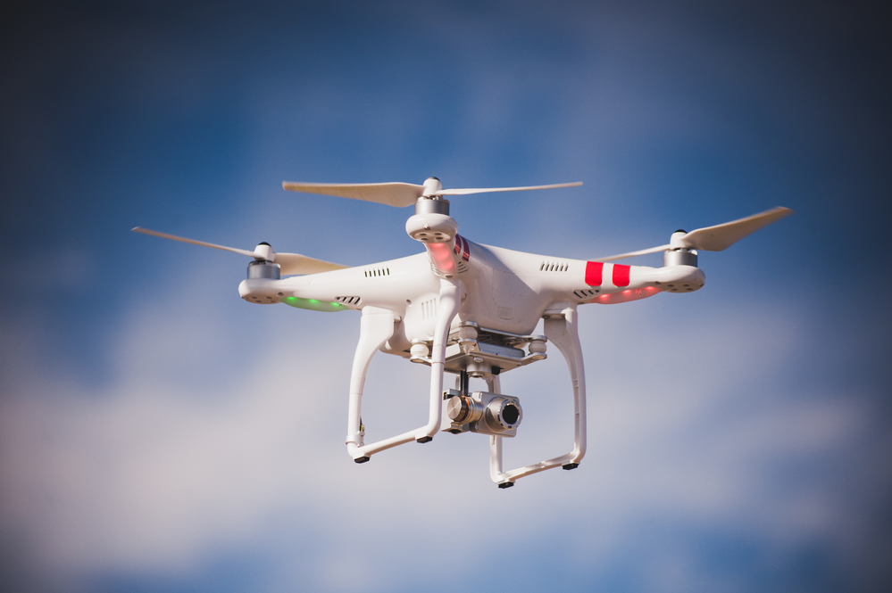
The past few years have seen tremendous advancement in UAS (Unmanned Aerial System) technology. UASs, AKA drones, are continually improving, adding better cameras, integrating obstacle avoidance sensors, and running autonomous flight routines. At DJS, we have been using UASs for a few years to aid us in our documentation and analysis of vehicular accident scenes. In what other areas might UASs prove useful?
Weather Damage Evaluation
Did a storm or high winds damage a building’s roof? Send a drone to inspect the roof as a whole, capturing high resolution images and video, which can be reviewed from the safety of your desk.
Structural Safety Inspections
Want to analyze the structure of a building to make safety determinations? Use the drone to capture imagery that can be utilized to produce a three-dimensional point cloud, allowing you to interact with rich, accurate data within the software on your computer.
Fire investigation/Building Collapse/Disaster Management
Combine photographs taken by a drone to produce a true orthographic plan view of a fire scene, building collapse or disaster area, allowing investigators to plot a grid over the site for forensic documentation.
Facility Management
Have a large outdoor facility with many components to manage? Drones have been utilized to document/survey the area, aiding in pinpointing locations in need of mechanical repair and documenting machinery as evidence preservation.
Landscape Management
Property claims near a golf course due to golf ball damage? Use drones to survey the land, and precisely show the relative distances between the damaged area, and the location the ball was struck from. This information could also be valuable in evaluating/updating course design.
Jon W. Adams is a FAA Licensed Drone Pilot, and Director of Architectural & Heritage Services at DJS Associates. He can be reached via email at [email protected] or via phone at 215-659-2010.
The post Why is the Drone My New Best Friend? appeared first on DJS Scans | 3D Laser Scanning.
]]>The post Federal Aviation Administrative LAANC Update appeared first on DJS Scans | 3D Laser Scanning.
]]>
The Federal Aviation Administration (FAA) just released a schedule for nationwide expansion of the Low Altitude Airspace Notification Capability (LAANC) Program. This expansion will begin in April, with new regions coming online in subsequent months. Here is the schedule:
April 30: South Central USA
May 24: Western North USA
June 21: Western South USA
July 19: Eastern South USA
August 16: Eastern North USA
September 13: Central North USA
As a reminder, the LAANC is a program intended to grant near-real-time authorizations for the vast majority of operations taking place in controlled airspace. Until these changes roll out according to the schedule above, Part 107 pilots will have to continue utilizing the online portal to request airspace waivers, which take a minimum of 90 days.
For additional information on Drone Technology, or to have a site droned by the FAA licensed drone operators at DJS Associates, please contact Jon Adams at [email protected] or via phone at 215-659-2010.
The post Federal Aviation Administrative LAANC Update appeared first on DJS Scans | 3D Laser Scanning.
]]>The post Documenting a Historic Icon appeared first on DJS Scans | 3D Laser Scanning.
]]>In late September 2016, I had the opportunity to put my UAS drone pilot certification to use on an exciting project on behalf of DJS Associates: The comprehensive documentation of a historic icon, the Ferryboat Binghamton. Working with RGA, Inc., DJS was contracted to collect critical measurement information, in order to help satisfy proper documentation protocols for sites that appear on the National Register of Historic Places. The Binghamton had been closed for several years after experiencing a second life as a popular floating restaurant on the edge of the Hudson River in Edgewater, New Jersey.
Hurricane Sandy devastated the abandoned ferryboat in 2012, and left it unsafe for boarding. DJS was able to combine 3D laser scans, taken from the shore, with 3D point data produced through photogrammetric image processing of photographs captured with the drone, to produce a highly accurate, 3D digital measured version of the Binghamton. This data was then utilized to produce the required CAD elevation views, satisfying the need for accurate documentation prior to demolition. Demolition of the Binghamton began in late July 2017, and is now complete.
Watch the process unfold!
Jon W. Adams, Director of Architectural & Heritage Services with DJS Associates Inc., can be reached via email at [email protected] or via phone at 215-659-2010.
The post Documenting a Historic Icon appeared first on DJS Scans | 3D Laser Scanning.
]]>The post FAA, Not State and Local Governments, Rule the Airspace for Drones appeared first on DJS Scans | 3D Laser Scanning.
]]>![]()
On September 21, 2017, a federal judge overturned a city ordinance in Newton, Massachusetts, which required all drones to be registered, bans drones below 400ft above ground level without property owner permission, and prohibits flights beyond the visual line of sight of the operator.
If these rules sound familiar, that’s because they are. Newton’s ordinance, passed on December 19, 2016 was overturned because it is pre-empted by the federal government. Judge William G. Young stated that “Congress has given the FAA the responsibility of regulating the use of airspace for aircraft navigation and to protect individuals and property on the ground, and has specifically directed the FAA to integrate drones into the national airspace.” Essentially, state and local governments cannot rule over their local airspace as that airspace is already ruled over by the federal government, the FAA.
This is good news for both recreational and commercial drone operators, removing yet another set of hurdles to get Unmanned Aerial Systems (UASs) in the skies. So long as you are operating under the FAA guidelines, you should not need to worry about any additional state/local restricitions.
For additional information on Drones, Jon W. Adams, Director of Architectural & Heritage Services at DJS Associates, can be reached via email at [email protected] or via phone at 215-659-2010.
The post FAA, Not State and Local Governments, Rule the Airspace for Drones appeared first on DJS Scans | 3D Laser Scanning.
]]>The post 3D Scanning Utilized to Help Local Custom Body Shop appeared first on DJS Scans | 3D Laser Scanning.
]]>DJS Associates was retained by Mike Snyder of Exotic Customs, Inc., a custom body shop located in nearby West Chester, PA to digitize a hand-fabricated prototype for a custom automotive grill. This digitization will provide Exotic Customs the ability to precisely refine the part as they move forward with its design.
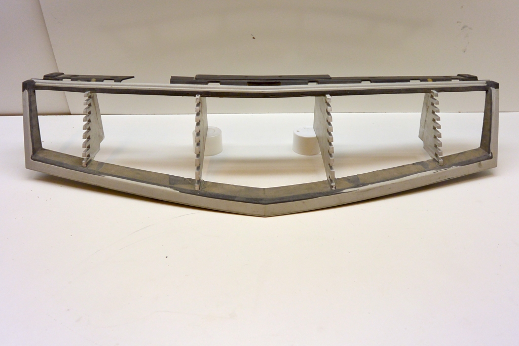
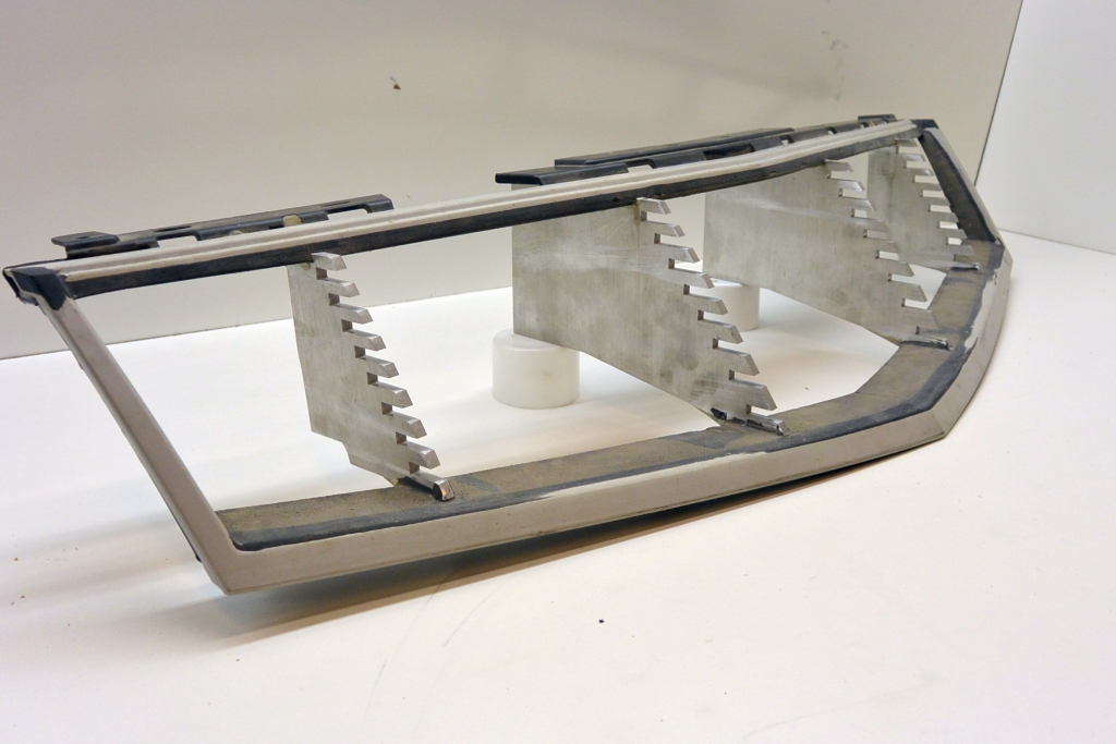
DJS’s arsenal of state-of-the-art data-collection tools and systems includes the Artec Eva handheld laser scanner. With a 3D resolution of 0.5mm, the Artec Eva allowed DJS technicians to capture all of the key details of the part, taking millions of measurements in a short period of time.
Within a few days, DJS incorporated the collected measurements into a 3D solid model of the part, and provided a highly optimized version to Exotic Customs. The digitized prototype will be used to finalize a “one-of-a-kind” custom grill for one of their many customers.
Jon W. Adams, Director of Architectural and Heritage Services, is available to answer your questions regarding 3D scanning. He can be reached via email at [email protected] or via phone at 215-659-2010.
The post 3D Scanning Utilized to Help Local Custom Body Shop appeared first on DJS Scans | 3D Laser Scanning.
]]>The post Did You Know: 3D Scans Improve Workflow appeared first on DJS Scans | 3D Laser Scanning.
]]>In this case, the artist was tasked with producing a sculpture, in the likeness of a person of interest who unfortunately is no longer with us. While the unique physical features of the subject’s face would require the careful attention and craftsmanship of the sculptor, the torso, arms and legs below could be more generic, as most human bodies tend to have common shapes. This is where 3D laser scanning could help.
Utilizing our hand-held 3D laser scanner, DJS was able to capture critical measurement data, digitizing the organic form of a stand-in model. The model, dressed in period appropriate clothing, stood motionless on a rotating platform, allowing DJS technicians to capture subtle details in a short period of time, using a highly accurate structured light laser scanner.
These laser scan measurements were then utilized to generate a watertight three-dimensional model, saved as a digital file. This digital file was used to allow a milling machine to generate an actual to-scale foam three-dimension model, which the artist was able to utilize as a template. In essence, the artist did not have spend precious time producing the rough form for the torso, arms and legs, and was able to focus their efforts on the face and head portion of the statue, which is arguably the most important.
Another great example of how 3D laser scanning can be utilized to provide the essential measurement information, serving as a foundation to produce an important deliverable, where accuracy is key.
For additional information on how 3D laser scanning can be utilized in case preparation and documentation, contact Jon W. Adams, Director of Architectural and Heritage Services at DJS Associates, at 215-659-2010 or via email at [email protected].
The post Did You Know: 3D Scans Improve Workflow appeared first on DJS Scans | 3D Laser Scanning.
]]>The post Tech Tip: Display Options for 3D Laser Scan Data appeared first on DJS Scans | 3D Laser Scanning.
]]>COST
First, let’s discuss cost. When putting together cost estimates for laser scanning projects, one of the first questions typically asked is: RGB, or no RGB? RGB (Red, Green, and Blue) is an acronym that is utilized to indicate whether or not color photographs are to be included in the data collection process. Ok, great… so what does this have to do with cost? If RGB is to be included, this means that the field technicians will utilize the “Scan with color” option on the 3D laser scanners, at each scan position. Color photographs will then be captured by the onboard camera, adding an average of 4 minutes per scan position (this can vary based on lighting conditions). As the old adage states, “Time is money”. Let’s review this idea in the table below. For simplicity, it has been assumed that a single scan takes 6 minutes.
| Number of scans | Scan time | RGB time | Total time |
| 5 | 30 minutes | 20 minutes | 50 minutes |
| 10 | 60 minutes | 40 minutes | 100 minutes |
| 20 | 120 minutes | 80 minutes | 200 minutes |
| 40 | 240 minutes | 160 minutes | 400 minutes |
As evident in the chart, choosing to include RGB color information can have a significant impact on the time aspect of 3D laser scanning, which relates directly to cost. So why include RGB color information?
DOWNSTREAM CONSIDERATIONS
Considering the multitude of uses for 3D laser scan data, the ability to include RGB color information is an important consideration when analyzing how this data can and will be utilized throughout its lifespan. Who will use this data? For example:
If the 3D laser scan data is only to be utilized for its highly accurate measurements (reference for 3D modeling/BIM, measurement analysis), RGB color information may not be necessary.
If the 3D laser scan data is to be utilized to show how an environment or object looks in real life (realistic animations and visual presentations), RGB color information can be invaluable in helping a viewer understand this “captured reality”.
Following is a quick comparison of RGB-mapped 3D laser scan data, and data which contains no RGB information (Intensity Display):
RGB Color Display

Intensity Display

Jon W. Adams, Director of Architectural & Heritage Services with DJS Associates can be reached via email at [email protected] or via phone at 215-659-2010.
The post Tech Tip: Display Options for 3D Laser Scan Data appeared first on DJS Scans | 3D Laser Scanning.
]]>The post Summary: 2015 Inaugural Drone World Expo appeared first on DJS Scans | 3D Laser Scanning.
]]> On November 17th and 18th, 2015, Jon W. Adams, with DJS Associates, Inc., attended the inaugural Drone World Expo (DWE) conference in San Jose, CA. Chief among the topics at DWE were discussions surrounding the proposed system for UAS (Unmanned Aircraft System) Traffic Management (UTM). The goal of this UTM is to effectively and efficiently integrate UAS traffic into the low-altitude airspace, emphasizing safety while allowing civilian operators to employ UASs for a multitude of functions. This UTM, which NASA hopes will be in full swing within 5 years, aims to provide increased aerial infrastructure as more and more UASs flood into US airspace on a daily basis.
Data Management in the Drone Age was another hot topic. In these times of rapid technological advancements, data capture and data processing are leading to mountains of data at an alarming rate. Drones are not only capable of capturing high resolution still images and video, but are also now being equipped with LIDAR (Light Detection and Ranging) sensors. Couple these data capture inputs with outputs such as orthomosaic/spectral imaging maps and photogrammetric point clouds and models, and it’s easy to understand how all of this data could quickly overwhelm IT departments.
Look to the future, and be prepared.
The post Summary: 2015 Inaugural Drone World Expo appeared first on DJS Scans | 3D Laser Scanning.
]]>